STAGE 10 (Sainte-Engrâce → Refuge Jeandel, 12 km)
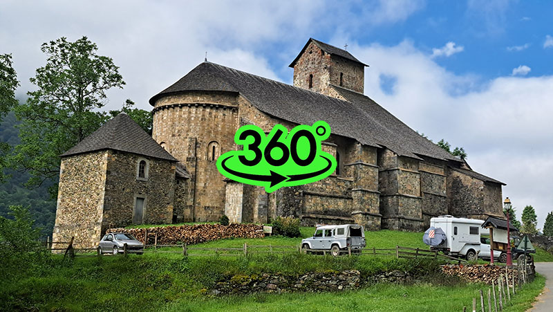
Sainte-Engrâce is a small but very picturesque village where the Romanesque church dominates the landscape. The Church of Sainte-Engrâce was built in 1085 by the Abbey of Leyre in Navarre. It was once an important stop for pilgrims on the Way of St. James (Camino de Santiago). Listed as a historical monument since 1841, it boasts 12 high-quality illustrated capitals. In the cemetery next to the church, one can find discoid steles—tombstones whose origins remain a mystery.
I ascended to the village just before ten in the morning. Since the village is a pilgrimage center, I expected an open inn where I could refuel. Ahead of me was a fairly steep climb, and I craved more substantial food than my dehydrated rations. To my disappointment, the only inn was closed. I stocked up on water, feeling frustrated that my hiking hours never seemed to align with the opening times of the rare establishments along the way. The church was fascinating, so I visited and documented it. I met an elderly French couple visiting in a motorhome and complained about my bad luck with food. They mentioned the inn opens at noon and suggested I wait. Soon, the innkeeper, who lived above, appeared and confirmed she opens at twelve, but added that she would only start preparing food then, meaning it wouldn't be ready until two or three in the afternoon. My crestfallen expression must have convinced her, as she offered to heat up one of her pre-prepared dishes for tourists. she had large glass jars—similar to those used for pickles—but hers contained stewed beef soup with vegetables. I agreed, and a few minutes later, she brought a steaming meat soup with fresh bread. The soup was rich with exceptionally tasty meat—exactly the hearty meal I needed.
Thanking her for her kindness, I set off on the tenth stage. From Sainte-Engrâce, I descended back to the GR10 markers and entered the fossil gorge of Arphideko Bidea, which is very similar to the Pokljuka Gorge in Slovenia. Here again, there is confusion with Basque-French names; the French name for the gorge is Ravin d'Arpidia. Walking through the 1.5 km long gorge in near-fog, I saw remains of long iron pipes, perhaps 30 cm in diameter. These were intended for a high-pressure water flow for a power plant, originating from the Verna cave. The tunnel to the La Verna cave was excavated between 1956 and 1960 by the French National Electricity Company (EDF) to capture underground water for power generation, but the project was abandoned due to technical difficulties. After half an hour, I reached a junction with worn information boards describing the construction and the artificial tunnel to the Verna karst cave, located 1 km south of the crossroads.
The Verna Cave, also known as Grotte de La Verna, is located in the commune of Sainte-Engrâce. This impressive cave is part of the massive La Pierre Saint-Martin underground system, one of the largest in Europe. Discovered on August 13, 1953, its most striking feature is the Salle de la Verna—a hall 250 meters in diameter and 194 meters high, covering 5 hectares. This makes it one of the largest cave chambers in the world. A river cascades from the eastern wall into the hall and disappears among the boulders at the bottom. La Verna has been open to the public since 2010.
From the information boards, I turned sharply left up a steep slope, transitioning from the hilly Basque Pyrenees into the high mountains toward the Arette-la-Pierre-St-Martin ski resort, where the Jeandel mountain hut marks the end of stage ten.
The climb from Sainte-Engrâce to Refuge Jeandel involves a 1,200 m ascent to an altitude of 1,760 m over 12 km, estimated at about five hours of walking. The path led through a dense beech forest with warning signs for logging. I soon heard the sound of chainsaws and crashing trees. I stuck to the GR10 markers as I had no other choice. The forest was humid and the atmosphere felt electric, making the ascent very unpleasant, heightened by the risk of falling trees. When I finally emerged above the tree line after two hours, I noticed thick storm clouds gathering around me. There was nowhere to hide. Common sense told me to turn back to Sainte-Engrâce. I had been hiking alone all day, and it seemed other hikers had been deterred by the poor forecast. However, the climb was grueling, and I didn't want to repeat it the next day. Checking the map, I had two hours left to the Col de la Pierre St Martin pass on the border between France and Spain. Scanning the clouds, I saw no lightning and heard no thunder yet, so I decided to push on quickly. I soon reached a mountain gravel road that wound past pastures toward the pass. The air grew heavier and more humid; I walked fast, stressed by the impending storm. As I reached the karstic plateau, a magnificent view of the snow-capped Pyrenean peaks opened up. Cattle grazed around me as I hurried, now hearing distant thunder that gave me an extra boost of speed. Below, I saw the serpent-like asphalt of the D132 mountain road and soon practically fell onto the parking lot at the top of the pass, where a few cars and motorcyclists were parked.
The Col de la Pierre St Martin pass sits at 1,766 m on the border between the French department of Pyrénées-Atlantiques and Navarra, Spain. Near the summit is the Arette-Pierre-Saint-Martin ski station. In 2015, on Bastille Day, the tenth stage of the Tour de France climbed this pass, marking the first time it hosted a stage finish.
Every year on July 13th since 1375, the "Tribute of the Three Cows" ceremony takes place at the summit. This is an annual gathering of people from the neighboring Pyrenean valleys of Barétous (France) and Roncal (Navarra, Spain). Held near the St. Martin stone, which traditionally marks the border, the people of Barétous hand over three cows to the people of Roncal as a peace tax paid annually for over 600 years. It is often cited as the oldest international treaty still in force.
The exact origin of the tradition is unknown, but evidence suggests it predates the 1375 legal arbitration. Though called a "tribute," it is a synallagmatic contract between equals, established with the mediation of a third party from Ansó. The arbitration decision was issued in Ansó (Aragón, Spain) on October 16, 1375. Official records of its celebration date back to at least 1575. The ceremony has been held almost every year since, interrupted only twice: in 1793 during the War of the Pyrenees and in 1940 during the Nazi occupation of France, when regional authorities feared residents would flee to Spain.
Thick fog caught up with me at the pass, forcing me to use GPS navigation as the path led onto the ski slopes with no visible trail. After a slight descent, I arrived at Refuge Jeandel. At that moment, the "mother of all storms" broke loose—hurricane-force winds and a tempest of thunder and lightning. I was incredibly lucky to have reached safety almost to the exact minute.