STAGE 9 (Logibar → Sainte-Engrâce, 25 km)
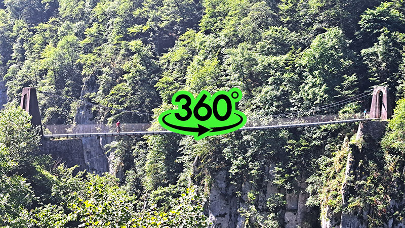
I set off from Logibar on the ninth stage toward Sainte-Engrâce. Crossing a wooden bridge next to the power plant, I crossed the Olhadoko erreka stream and began ascending the right bank of the d'Holzarte gorge. The area consists of limestone layers several dozen centimeters thick, separated by bedding planes. What began as a pleasant, gentle forest path soon turned into a steep trail covered with slippery limestone rocks, revealing a precipitous drop and views of the picturesque gorge. The path leads into the right branch of the d'Holzarte gorge, the d'Olhadubi gorge, above whose left bank slopes covered with dense beech forest stretched out. Soon—about an hour after the ascent from Logibar—I reached the imposing Holzarte suspension bridge, which spans 70 meters in length and hangs 150 meters above the canyon floor. The bridge was built in 1920 by Italian builders who were then employed by the Lombardi Morello forge.
The local names here can be quite confusing for a foreigner. The Holzarte gorge is called the Olhadibi gorge in Basque, and the various names on maps can easily mislead those unfamiliar with the terrain and language. The path from Logibar to the suspension bridge is very popular and serves as a major tourist attraction. While I was documenting the surroundings using spatial photography, a group of retired French tourists caught up with me... well, "retired"... the group included men and women practically my age.
"It's easy for you, being so young and still having the strength for such a demanding path as the GR10," they told me. After I explained that we were peers, they became less patronizing, and at least the "ladies" began looking at me with a bit more respect (ha-ha).
After a short break and a snack, I set off along a winding mule track, now on the left bank of the Olhadibi gorge. Two women in their thirties, a romantic couple from the French and Spanish parts of the Basque Country, caught up with me. As we walked, we struck up a conversation about hiking in the Pyrenees.
The path became gentler, so despite my heavy backpack, I managed to keep pace with them. Only for a short time, though, as they sped ahead after half an hour. I stopped by a large pool of a left tributary to the gorge. I had run out of drinking water, so I refilled my reservoir and added a chlorine tablet, as I didn't know what lay in the stream's headwaters. The day became humid and I was drenched in sweat, so I took a quick dip in the pool and rinsed my wool t-shirt, which had already started showing white salt crusts from perspiration. Continuing the path, I reached a small bridge crossing the Olhadibi stream. Below the bridge were small pools where my Basque acquaintances were sunbathing. The natural basins looked very inviting. The day was hot, so I didn't hesitate to refresh myself in the stream despite the icy water. We waved goodbye, and then I headed along the right bank of the gorge, gently ascending but in the direction back from where I had come. The right bank is not as densely overgrown as the left, opening up a panorama of the left bank and the path I had previously climbed. After an hour of moderate ascent under extremely picturesque, dome-shaped stone peaks, I reached a junction leading to a circular path back to Logibar and the GR10 direction toward the Cayolar Ardakhotchia pastures. The pastures were open-range for cattle, where fortunately I didn't notice any overly curious bulls. As the afternoon progressed, I began thinking about finding a place to camp. The area was full of livestock, so I decided to continue until I was outside the grazing zone. After two hours, I reached the Anhauko Kurutxe pass (Col d'Anhaou, 1383 m), where a narrow asphalt road led downward. Along the road were shepherd huts. Craving local cheese, I stopped at the first one that showed signs of life after two kilometers. I dropped my heavy pack and a young man, about 15 years old, appeared and addressed me in excellent school English. I asked if I could buy a wheel of cheese. His grandfather soon joined us. They spoke in Basque for a moment, then told me I couldn't buy the cheese. I was disappointed, but after a few seconds, they both smiled and said I could have the cheese for free. They brought out a wheel of cheese, sliced it, and even offered a whole baguette. The cheese was delicious, making for a hearty dinner. I thanked them warmly and even received a bar of chocolate for the road. The immense Basque hospitality lifted my spirits, and since the evening was still bright, I headed toward my destination, the village of Sainte-Engrâce, about two hours away.
Of course, the weather in the Pyrenees is fickle. After half an hour of walking down the road, the wind picked up and clouds began descending from the surrounding hills. I found a nice scenic clearing set back from the road, quickly pitched my tent, brushed my teeth in a nearby stream, and went to sleep by 9 PM.
In the morning, I woke up to thick fog, with large droplets on the outside of the tent merging into small streams of water. I had no appetite for breakfast, so I packed the wet tent and headed down a slippery path toward the Kakuetta gorge. The fog was dense, so documenting the path with spatial photography was out of the question; I only managed a few 360-degree panoramas. I descended to the Lac de Kakuetta river lake but didn't enter the gorge itself due to the fog. Since entry to the Kakuetta gorge has been prohibited since 2020 due to falling rocks—a falling stone recently killed a young mother on a trip—I had planned to "play the tourist" and enter at my own risk. However, visibility at the entrance was very poor, and the previous days of heavy rain had likely made the gorge walls even more unstable, so I didn't want to tempt fate. Still, the desire to visit sometime in the future remains.
The Kakuetta Gorge is undoubtedly among the most beautiful canyons on the French side of the Pyrenees. Deeply carved into mountains formed about 80 million years ago, it winds like a snake along steep walls for two kilometers before ending at a cave. Due to the lush vegetation and ferns, visitors often describe Kakuetta as the "Basque Amazon."
The Gorges de Kakouetta were discovered in the steep mountains of the Saint-Engrâce area. They were only truly explored in the 20th century. Although some exploration was documented as early as 1892, the gorge remained a mysterious secret until speleologist Édouard-Alfred Martel explored it in 1906.
Somewhat disappointed, I followed the GR10 signs and, after an hour of walking, arrived at the village of Sainte-Engrâce, where the ninth stage concluded.