STAGE 7 (Kaskoleta → Chalets d'Iraty, 20 km)
From Kaskoleta, I tackled the seventh stage at three in the afternoon. The sun peeked through the clouds, filling me with energy. The path was gentle, and I barely noticed the hundred-meter elevation gain from Kaskoleta to the Col d'Ithurramburu pass (808 m). After the pass, the trail turned onto a cart track leading down into the head of the valley of the Intzarazkiko Erreka stream. Does the name sound familiar? The Slovenian word for river is *reka*, and the Basque word is *erreka*.
The track descended steadily... gently at first, but after dropping 200 meters in altitude over an hour, I had covered quite a distance before reaching the stream—now more of a brook—where an abandoned mill stood. A sharp turn and about another kilometer of gentle climbing brought me to a small clearing with a tent already pitched, where Ron from Alsace was waiting. He had overtaken me because I took the detour before Estérençuby while he stuck to the old shortcut.
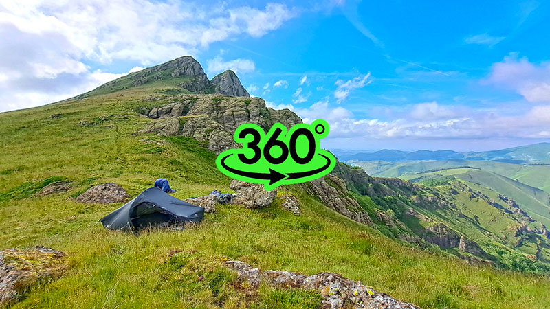
The clearing barely had room for one tent and the gorge was quite narrow. Since I prefer pitching my tent at spots with better views, I decided to push on, even though the path headed up a narrow and very steep trail toward the Col d'Irau (1008 m). I conquered the four-hundred-meter ascent to the pass and began scouting for a suitable campsite. Before me rose Mount Iraukotuturru (1151 m), its peak now only 150 meters above me. With sunset approaching, I climbed just below the summit, found a safe viewing platform, and set up my tent.
The location was 'mystical'—picturesque rocks, vast views, and a stunning sunset...
A fairly strong wind began to blow, which I used to dry my tent, still wet from that stormy night in Saint-Jean-Pied-de-Port. I prepared a hearty dinner and settled lazily into the lee between the tent and a large rock, watching the landscape in the valley below.
Despite the wind, I slept safely and soundly until morning, missing the sunrise. I was in no hurry; a beautiful day was forecast before a period of bad weather with orange and red storm warnings. After breakfast, I packed up, prepared for navigation, and walked along the long ridge of the pass, almost level, to the foot of Sommet d'Ocabe (1466 m). As it was a beautiful morning, I eagerly documented the route, which slowed my pace. Ron caught up with me, along with another French traveler, Marc. All three of us were roughly the same generation, "almost" sixty... the conversation flowed in German and my mostly useless French, but we understood each other. I learned that Ron was a retired police officer, and Marc was a retired professional soldier from a rapid-action paratrooper unit. As a war veteran with a twenty-year history in military police units, I had a similar 'pedigree,' so we quickly found common ground and reached the top of Sommet d'Ocabe in no time.
Below the summit, stone circles erected 4,000–5,000 years ago are visible, known as the **Cromlechs d'Ocabe**. These stone circles served as burial sites for important Basque ancestors.
The first description of this magnificent array of protohistoric tombs on the Occabé plateau dates back to 1914. René Gombault conducted the first excavations on two monuments, though the results weren't published until 1935. These excavations continued in 1968–1969, bringing the total number of monuments to 26. They are located in the heart of the Iraty region, at the center of the Basque mountain ranges. The vast pastures of the Occabé plateau occupy a privileged position at the center of an extensive network of ancient transhumance routes. The archaeological complex includes an impressive 10 dolmens, 63 burial mounds, 107 *cromlechs*, and 232 remains of hut foundations.
*Cromlech* (from Breton: *crom llech* = "bent stone slab") is a prehistoric megalithic structure of stones set in irregular circles or ellipses. In the Neolithic, they held ceremonial and religious significance or were part of larger structures like passage graves.
The ancestors of the Basques knew well where to place their sacred sites: usually in places with beautiful panoramas. Indeed, walking among the stone circles, I felt an unexplained sense of "ancientness."
The path from the Occabé plateau descended gently into a dense beech forest, considered the largest and most beautiful in the Pyrenees. Literature even claims the Iraty forest is the largest beech forest in Europe.
A quick descent down a winding forest track brought us to a local asphalt road within an hour, and then to Chalet Pedro, a mountain guesthouse tucked into the woods. We treated ourselves to cold beers and large ham sandwiches. Since opportunities for drinking water were scarce, we each stocked up on several liters. I need about half a liter per hour of walking, so I always carry at least three liters of reserve, though the extra weight is noticeable in the backpack. From the guesthouse, we set off along the D19 road for about two kilometers through the picturesque valley of the Urbeltza stream, a popular recreation area for motorhomes. Before reaching Chalets d'Iraty, we took a shortcut toward the Lac d'Iraty reservoir. It was a shortcut only in terms of air distance; in reality, the steep climb and subsequent descent to the lake took longer. From the lake, another climb led to the mountain recreation center, Chalets d'Iraty, where Stage 7 ended.
Chalets d’Iraty were built in 1966 as part of a broader effort to develop the region for both pastoral and tourism purposes. They have since become a popular destination in the Basque mountains, offering a unique combination of natural beauty and cultural heritage.
Ron and Marc had enough walking for the day and decided to stay at a nearby campsite, but I pushed on into Stage 8 toward Logibar. It was only three in the afternoon, so I decided to continue until dusk and then pitch my tent somewhere along the way.