STAGE 3 (Ainhoa → Bidarray, 21 km)
For Vincent, Ainhoa was the final stop at the end of Tuesday's second stage, as his pre-booked accommodation was already waiting for him.
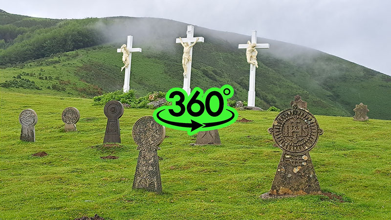
I myself, though already exhausted—mainly from the rain—continued into the third stage. After nearly an hour of quite steep hiking with a 250 m ascent along a Calvary path, I rose above Ainhoa to the chapel of 'Our Lady of Aranzazu' (Notre-Dame-d'Aubépine) from the end of the 19th century. On the level ground where the chapel stands, there are three characteristic Calvary crosses, and nearby is an old cemetery with Hilarri headstones. Hilarri (from the Basque *hil* 'dead' and *harri* 'stone') is the name for the disc-shaped funerary steles characteristic of the Basque Country.
These funerary steles feature a disc-shaped head facing the rising sun on a trapezoidal pedestal. They belong to an ancient tradition found throughout the western Mediterranean, including parts of Europe and North Africa, but today they are most commonly found in the Basque region.
Before I even reached the chapel, a heavy downpour caught up with me, turning into a storm, so I sought shelter in the chapel's porch. It was five in the afternoon, and being quite tired, I considered pitching my tent right there by the chapel. However, the ground was very waterlogged from the heavy rain, and the idea of setting up camp didn't appeal to me. I used the time waiting out the storm to prepare a hot meal and debated with myself whether to continue walking and find a more suitable spot for the night.
The storm passed, the hot meal did me good, and I rested enough to find new momentum. I studied the map for potential camping spots along the way, saw there would be several after an hour's walk, and decided to push on.
The path led me past a small, old iron ore mine that operated here until the end of the 19th century, then onto open pastures where large flocks of sheep grazed. Another wave of rain hit, and the large umbrella I had bought in Hendaye—now my trademark on the trail—came in handy. While a rain poncho is standard hiker protection, the umbrella was invaluable during the heavy rain arriving in waves. I could tilt it toward the wind so the annoying drops didn't beat against my face.
Following a path that turned into a cart track, I passed more flocks of sheep and, after two hours of walking, reached a ridgeline pass where the rain finally stopped. I quickly chose a spot for my tent, but the storm caught me once more, forcing me to set up camp in a heavy downpour. I inflated my mat, rolled out my sleeping bag, and fell into a weary sleep to the sound of raindrops.
I woke to a cloudless morning with a rising sun, which lifted my spirits as the previous day's rain had dampened my mood. After a hot breakfast, I set off at seven in the morning. The morning turned into a sunny and very warm midday. The humidity was high, and I was soon soaked in sweat. I quickly realized I was running out of water, and finding a source became a problem. Large flocks of sheep grazed on the surrounding hills, and while I crossed a few streams, their water didn't tempt me at all. I had a water filter and disinfection tablets, but I only used them once I reached a stream where I judged the terrain above it was unsuitable for grazing.
The journey continued right along the French-Spanish border, marked by boundary stones. I arrived at the Col des Veaux road pass (550 m), where a steep asphalt road led to the Col de Mehatche (716 m). Small groups of mares with foals grazed freely along the path, ignoring me as I approached. Just in case, as I didn't want to risk a kick, I gave them a wide berth. On this sunny and hot day, several cyclists overtook me on the road, heading for the Artzamendi peak (926 m) topped with a communication tower. Near the pass are ancient menhirs with information boards, unfortunately only in French.
From the pass, the path began to descend gradually across the plateau. Behind me, I felt the wind pick up and saw a dark curtain of storm clouds rapidly approaching. A beautiful sunny day turned into a thick cloud and then very heavy rain in minutes. The umbrella saved me again, as hailstones began to mix with the raindrops. Exposed in the open, the umbrella was my only protection against the stinging hail. Just before the steep descent into the valley, there was a shelter for goats, which had huddled in front of the locked entrance to escape the hail. They bleated frantically, but I chose to move away and wait for the storm to subside before tackling the steep descent. The way down was over stony ground made slippery by the rain, across scree slopes and above a precipitous bank.
Once I left the steepest part of the path at the head of the gorge, I suddenly stepped onto a narrow asphalt local road that wound alongside the Bastan stream toward Bidarray. The sun came out strong, and the air turned humid and hot. In the distance, I heard the voices of a playful crowd and soon came upon a local river bathing spot, where boisterous schoolchildren were enjoying a sports day. Another hour of walking on asphalt brought me to the end of the third stage in Bidarray. Once again, I hoped to buy fresh supplies or enjoy a restaurant meal. Once again, I was unsuccessful. The French (Basques) strictly adhere to their split working hours. At 2:00 PM, I arrived in a ghost town; everything was closed. I could only refill my drinking water from the taps in the public toilets. I was starting to prepare a hot meal in a small park when the sun vanished into clouds and heavy raindrops began to fall. I retreated to the toilet entrance area, which also offered public showers—except I couldn't use them, as they required tokens only available at the (closed) shop...