The upper course of the Soča ends at the Napoleon Bridge below Kobarid.
From Trnovo village to Kobarid, the Soča runs through a deep gorge rich
in pools, rapids and enormous rock lying in the riverbed. Before reaching
the bridge the river runs through the so-called Korita which is a section
about 200 meters long, up to 15 meters deep and only 2 meters wide at the
narrowest point. It is typical for its pools eroded in the rock, and the
vertical layers of limestone called Cepljena Skala (the Split Rock). The
historian Simon rutar wrote in 1882 that "the Soča riverbed" is the narrowest
below the Kobarid bridge where the water runs, deep down between two rocks,
like an arrow pulled from a tight quiver...
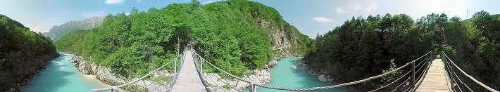
The two banks of the Soča are connected with a new, 52 meters long
suspension footbridge, made exactly at the location of the bridge from
World War I. The wooden footbridge was built by the Kobarid Museum and
and the Kobarid Tourist Society in 1998. |