Three national parks protect the exceptional biodiversity of the Pyrenees, which hosts several hundred endemic species: Pyrenees National Park in France, Aigüestorts i Estany de Sant Maurici National Park, and Ordesa y Monte Perdido National Park in Spain.
The Pyrenees are crossed along their entire length by three high-altitude hiking trails from the Atlantic to the Mediterranean: the GR 10 on the French side, the GR 11 on the Spanish side, and the HRP (Haute Randonnée Pyrénéenne), which follows the high ridges.
This travelogue with Virtual Reality visualization describes the experience of walking the GR10 trail (Le sentier de grande randonnée 10), which covers approximately 1,000 km (official length 953 km) and includes 54,000 meters of vertical ascent.
The GR10 Trail
On June 8, 2024, I traveled from Ljubljana early in the morning via GoOpti to Treviso airport, and after a layover in Brussels, finally landed at Biarritz airport. My twenty-two kilogram backpack, containing all the necessary gear for mountain hiking, safe camping, and of course, photography and landscape documentation, had to be checked as oversized luggage. The Osprey Atmos 65 AG backpack was packed to the brim: a Robens Chaser 2 tent with a theoretical wind resistance of up to 200 km/h, a RAB Neutrino Pro sleeping bag with a comfort rating of -5°C (I know, summer... but it later proved to be a good decision), and a comfortable inflatable mat with an R-value of 5. My clothing was minimalistic: two quick-drying RAB long-sleeve shirts, a merino short-sleeve shirt from Decathlon, three pairs of sports underwear, three pairs of merino hiking socks, a lightweight Mac in a Sac down jacket, and a RAB Kinetic 2 waterproof shell. Additionally, I carried spare hiking pants and waterproof rain pants.
In Biarritz, I was met by cloudy weather with a light drizzle. From the airport, I walked 2 km to the railway station, where I quickly caught a connection to Hendaye. At the airport exit, I was surprised by document checks and heavily armed military patrols of young soldiers, almost children.
I originally planned to buy a gas canister for my stove at the Decathlon in Hendaye and then head from the beach in Hendaye to start the first stage. I also brought quick-prep meals, as there were expected to be few options to buy compact long-distance trekking food along the way.
The rain intensified, and the weather app predicted a red alert for rain and storms. During the train ride to Hendaye, I used the Booking app to find accommodation and located a suitable pension/'Gite' 4 km outside of Hendaye. The worsening rain and the walk from the station to the lodging initially made me feel discouraged. However, arriving at 'Gite Amaia Baita' lifted my spirits. It's interesting how some Basque words are semantically similar to Slovenian. I was greeted by a friendly owner in what turned out to be a B&B where the host shares his home with guests. It was a beautifully maintained property with imaginative interior design. The afternoon weather update was not promising, confirming storms for the following day, Sunday, with the bad weather likely persisting into Monday.
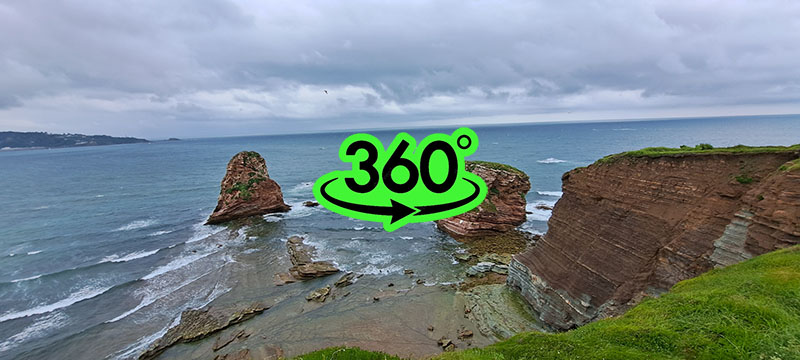
Sunday night was stormy with lightning and heavy thunder, and I woke up to a light drizzle. The coast east of Hendaye consists of cliffs and intense erosion, so I decided to take a walk to Hendaye to explore the coastline despite the wet weather.
The roughly six-kilometer coastal path to Hendaye was soaked from the night's storms, and after about half an hour, a strong wind began to blow with rain. A small, lightweight foldable umbrella lasted less than three seconds; the moment I opened it, the wind literally crushed it, leaving me with just the handle. My shell jacket did its job, and despite the now heavy rain, I stayed dry. In Hendaye, I tossed the broken umbrella into a bin and, in a moment of inspiration since the lashing rain was unpleasant, bought a large, sturdy umbrella that accompanied me for the rest of the journey despite its weight.