STAGE 13 (Etsaut → Gabas, 25 km)
The thirteenth stage runs from Etsaut to Gabas and is 25 km long with 1,600 m of ascent and 1,200 m of descent.
Leaving the rainy Basque Country behind, I set off south from Etsaut along a local paved road on the left bank of the torrential Le Gave d'Aspe river towards the Fort du Portalet. By now seasoned, I stoically endured the light drizzle (thinking to myself that I might soon grow gills...) and after a good kilometer of asphalt, I began to climb above the fortress along a stony path similar to a mule track.
Fort du Portalet in the Aspe Valley in Béarn, French Pyrenees, was built between 1842 and 1870. Constructed by order of Louis Philippe I, it was intended to guard the border and defend the access to Col du Somport. Initially, 400 soldiers were stationed here. Between 1871 and 1925, the fort served as a warehouse and barracks for the 18th Infantry Regiment.
During World War II, the French collaborationist Vichy regime interned Léon Blum, Édouard Daladier, Paul Reynaud, Georges Mandel, and Maurice Gamelin as political prisoners in this fortress. After the Riom trials, Reynaud was moved to German custody. Mandel was taken to Paris, where he was executed by the militia in 1944. After the war, Philippe Pétain, the leader of the Vichy government, was imprisoned in the fort from August 15 to November 16, 1945.
Just above the fortress, the trail turned sharply left onto a stone path carved into the precipitous cliffs called the Chemin de la Mâture, above which steep rock overhangs towered. Below the stony path, made slippery by the rain, dropped a steep abyss that deepened as I climbed. There are no guardrails at the edge, but for a sensible hiker, there is no danger of falling.
The Chemin de la Mâture is a 1,200-meter-long path carved into the cliff face above the valley of the La Secoue stream. The trail features a four-meter-high and up to four-meter-wide carved groove, mostly around one and a half meters wide.
From 1660, King Louis XIV and his minister Colbert decided to provide France with a grand navy. Facing difficulties obtaining timber from the north due to wars and costs, Colbert decided to exploit the forests of the western Pyrenees, which offered large, high-quality trees and transport routes via the Gaves to the port of Bayonne. This allowed several forests to be economically utilized. After a break between 1720 and 1750, exploitation peaked in the second half of the 18th century during the reign of Louis XV. The construction of the transport route was entrusted to the Navy Corps of Engineers and completed in 1722. Timber exploitation for the navy in the Aspe Valley ended in 1778 due to the harvesting of all available trees.
I left the rock-cut path as it transitioned into the forest; the rain stopped, and the sun began to peek through the clouds, instantly making the atmosphere muggy. I heard thunder above me, which ceased during the ascent through the wooded landscape. I climbed to an altitude of 1,600 m, where the path leveled out and the forest gave way to grassy slopes. I entered the Pyrenees National Park (Parc national des Pyrénées). The distant thunder stopped, but a light drizzle remained. About 50 meters away, I saw the carcass of a large cow, still steaming—it had clearly been struck by lightning very recently. Dozens of griffon vultures had already gathered around the body to begin their "cleanup operation." I climbed steadily through the valley toward Col d'Ayous and Pic d'Ayous (2,288 m). After two hours of slow ascent, it was still drizzling, and I arrived just below the edge of a large cloud covering the pass area. It was eight in the evening, so I decided to pitch my tent and stay the night. Camping is not allowed in the national park, but there is an exception for hikers to pitch a tent and stay from 7:00 PM to 7:00 AM. I moved off the path toward a stream flowing from the cirque and set up my tent on a grassy ledge. Luckily, the drizzle finally stopped, allowing me to prepare dinner and wash in the stream. Due to the humidity, it began to cool unpleasantly, so I wrapped myself in my down sleeping bag and fell into a deep sleep until morning light.
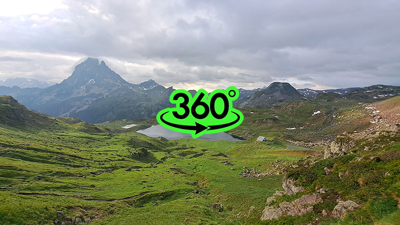
The morning was cloudy but fortunately rain-free. After breakfast, I packed the tent and quickly climbed to Col d'Ayous. The surrounding mountains were shrouded in thick clouds, so I was unlucky with the views. However, there was a magnificent view of Pic du Midi d'Ossau, which at 2,884 m is only twenty meters higher than Slovenia’s Triglav. Despite the mountain wearing a cloudy cap, the sight was exceptionally picturesque.
The summit of Pic du Midi d'Ossau was first conquered in 1552 by an expedition led by François de Foix-Candale, who later became the Bishop of Aire.
Because of the clouds, I abandoned the ascent to the summit of Pic d'Ayous, which was only a few minutes away, and descended into the glacial valley where the Refuge d'Ayous mountain hut sits by the picturesque Lac d'Ayous. It was early morning, and dozens of tents were pitched around the lake. The hut was already open and fully occupied. I craved a hearty breakfast, but because I wasn't an overnight guest, I couldn't order a meal. The hut manager almost begrudgingly offered me a packet of crackers for €5. The logic of mountain huts in the Pyrenees is completely foreign to a hiker used to the hospitality and well-stocked nature of Slovenian mountain posts.
I quickly left the Lac d'Ayous area and descended via a mountain path past picturesque waterfalls and a lower lake into the valley toward Gabas, the final destination of the thirteenth stage.