Soča River source and waterfalls
 virtual excursion virtual excursion
 JULIAN ALPS
The Soča River originates in northwestern Slovenia from a karst source at the foot of Travnik in the Mangrt-Jalovec mountain range in the Julian Alps. The river is 139 kilometers long and flows south of Tržič into the Gulf of Trieste. The Soča flows 96 kilometers through the territory of the Republic of Slovenia and 43 kilometers through the territory of the Republic of Italy.
The karst spring is located in the Triglav National Park near the Vršič pass (1611 meters), which connects Trento ob Soči with Kranjska Gora on the other side of the Triglav National Park. At the town of Soča, the left tributary Lepeno before Bovec gets the right tributary Koritnica. In this section, the Soča flows through a 750 m long and 10 to 15 m deep gorge. Here is also the oldest, 20 km long hiking trail, which crosses the river in several places over the typical wooden suspension bridges.
From the Lepena estuary through the gorge to Kobarid, the Soča is popular for kayaking. The clear water of the Soča is crystal clear and turquoise blue. Due to the location of the Soča, which flows through the valley open to the Adriatic Sea, the climate is mild both in spring and late summer.
At Gorizia, the river enters the eastern end of the Northern Italian Plain, flows through Italy in the last quarter and carries large amounts of alluvium to the Adriatic Sea. Here, the Soča River refers to this region's characteristic wide gravel torrent bed, which changes with each high water and requires long bridges to bridge. In summer, however, the riverbed is almost empty.
The Soča was called Sontius in Latin and in some sources was a tributary of the Cold River (Fl. Frigidus), which is supposed to be today's Vipava River. It is also assumed that the Cold River (Frigid) is actually the Soča River. The name of the river and the 'extraordinary cold' mentioned by Claudius also speak of this, as the Vipava is not particularly cold as a flat river. Perhaps Roman geographers have already argued about the mainstream: Herodian describes the river - without naming it - as “large and excellent, fed especially in spring and summer by snowdrifts from the Alps, which is not the case with the Vipava River. On the other hand, Castra ad Fluvium Frigidus was probably close to Ajdovščina, and the Battle of Frigid 394 is historically geographically located between Ajdovščina and Vipava. In any case, it is archaeoclimatically possible that the lower reaches of the Isonzo were not a torrent in Roman times. The Tabula Peutingeriana (a copy of the 13th century, a Roman illustrated map of ancient Roman routes) shows the mouth of a large lagoon, not - as today - directly in the Gulf of Trieste. At that time, Vipava could also be much richer in water and fed by many cold karst springs.
The source of the Soča
Loška Koritnica springs between Mangrt (2,679 m) and Jalovec (2,645 m). Its tributaries have an extremely varied riverbed with many waterfalls. The spinning mill is a right tributary of the Koritnica. Its highest waterfall is a good 50 m high Predelski waterfall. The Zaročenca waterfall (30 m) and the Oblique waterfall (20 m) are also worth mentioning. Fratarica is a left tributary of the Koritnica. It springs below Oblica (2,246 m).
The stream makes as much as 1,000 m of altitude difference on its short route. The highest waterfall consists of three levels Veliki Drsnik (112 m). The Skok waterfall (Parabola; 48m) is easily accessible in the Loška Koritnica valley. In the lower course, the Koritnica gets a rather strong right tributary - the Možnica stream (old name Nemčlja). Interesting are the gorges and the 18 m high Veliki Možniški waterfall, which falls under a natural bridge. The river Koritnica makes its way through a 1 km long canyon between Rombon (2,208 m) and Vrh Krnice (2,234). Its approximately 60 m deep and 200 m long troughs are known. They are best seen from the bridge at the Kluže fortress.
In 1981, the extremely picturesque Trenta Valley was included in the Triglav National Park. In the lower part, near the settlement of Soča, it merges with the town of Vrsnik, near the settlement (Trenta) Na Log, towards the east it meets the valley of Zadnjica, and towards the north it passes into the valley of Zapoden.
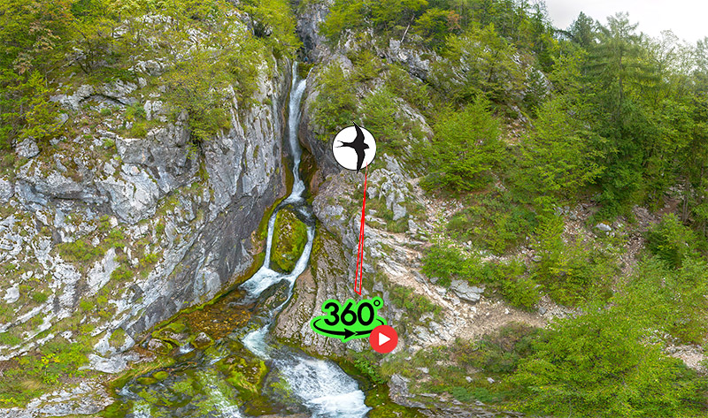
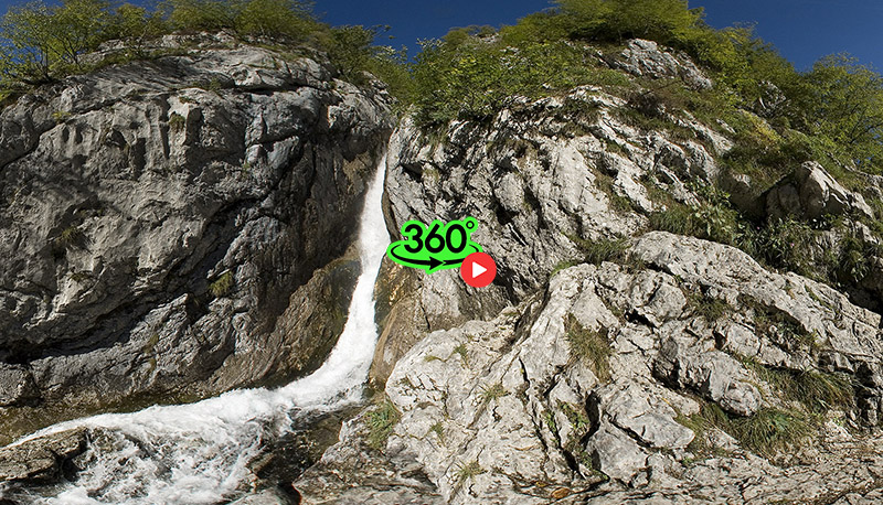
Suhi potok flows through the Zapoden valley. In the upper course is officially the highest permanent waterfall of the Triglav National Park: Waterfall below the mountain Zapotok (121 m). At the confluence with the Soča, Suhi potok contributes most of the water. Not far from the confluence, at an altitude of 1,050 m, the river Soča originates in one of the most beautiful karst springs. Karst spring is a popular tourist destination. As a curiosity: the old name for the Soča in the upper course between the spring and the settlement (Trenta) Na Log was Šnita. In this part, the river also gets smaller tributaries. The left tributary of the Mlinarica is known for its deep troughs. Access to the lower 8 m high waterfall and to the 'entrance' to the gorge is tourist-oriented. Nearby is the Julian Alpine Botanical Garden, which houses over 1,000 specimens from the Alpine world, mostly from the Julian Alps. Above it rises the Red Graben, along which descends almost 200 m high waterfall. The center of Trenta is the village (Trenta) Na Logu. Above it rises the steep gorge of Kloma, along which the torrent flows. He overcomes the slope in a 200 m high waterfall. With a strong flow, it could be considered a 200 m high multi-stage waterfall. East of the settlement (Trenta) on the Log flows into the Soča its left tributary Krajcarica. It flows through the Zadnjica valley. Beli potok is worth mentioning here, with its 15 m high lower waterfall. In the lower part of Trenta, the Soča flows in the Small Troughs, below which the Vrsnik stream flows from the left. The place where the stream flows is also called Vrsnik. On its way, the Vrsnik stream has carved interesting troughs, about 150 m long and up to 15 m deep. The waterfalls under the troughs are also interesting. During the rainy season, Vrsnik gets a torrential tributary from the left. It creates an extremely picturesque, more than 100 m high waterfall. The waterfall is not permanent. Its right tributary Suhi potok flows through deeper troughs than Vrsnik.
A popular starting point for Lake Krn and on to Krn (2,244 m) is from the Lepena valley. The Lepenca stream springs in a 'pool' 1x1 m at an altitude of 1,100 m, below Debeljak (1,869 m). This area was extremely affected by the earthquake in 1998, so that the waterfall and the troughs below it were flooded. The filled material was quickly carried forward by the water into the valley. The left tributary of Lepence is the Šumnik (Šunik) stream. It has an extremely strong constant flow. In many waterfalls it descends past unusual layers of rock.
The headwaters of the Tolminka and Zadlaščica rivers, known for their deep riverbeds, hide quite a few, unknown 'streams. The right tributaries of the Tolminka, the Levi and especially the Desni Pščak create extremely picturesque waterfalls. In the wild ravine of the right tributary of the Zadlaščica - Jelovšček, there is a unique 20 m high "spiral waterfall".
Literature:
Boštjan Burger, Slapovi Triglavskega narodnega parka, 1998, COBISS.SI-ID - 97736192;
Levi, Analina; Levi, Mario (1967), Itineraria picta (in Italian), Rome: Bretschneider;
Skoberne, Peter One Hundred Natural Sights of Slovenia, Ljubljana, 1988;
Rojšek, Danijel, (1991). "Natural sights of the Soča region". State Publishing House of Slovenia, Ljubljana.
|