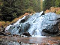

Pohorje is an alpine mountain ridge with rounded peaks situated south of the Drava River. It lies within a triangle formed by the towns of Maribor (to the east), Dravograd (to the west), and Slovenske Konjice (to the south). To the northwest, it is bounded by the Mislinja River, to the south by the Vitanje Basin (Vitanjsko podolje), to the east it descends into the Drava Plain (Dravsko polje), and to the southeast into the sub-Pohorje hills (Podpohorske gorice). It measures approximately 50 km from east to west and 30 km from north to south, covering an area of about 840 km². Its highest peak is Črni Vrh (1,543 m). Dense forests cover more than 70% of the entire Pohorje area.
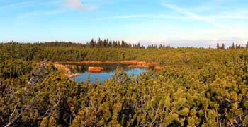
Lovrenško barje is the largest high peat bog in Slovenia. The peat bog consists of two parts separated by a narrow strip of spruce forest. The defining feature of this unique wetland is a group of 20 small lakes, also referred to as bog windows ("barska okna") — giving rise to the name Lovrenc Lakes. These water bodies are the result of shallow depressions in the underlying bedrock. The peat bog occupies a ridge position (at an altitude of ~1,520 m) and originally originated as a mineral swamp on an undulating, impermeable geological bedrock. Over millenia, the raised bog developed through the gradual accumulation of sphagnum peat. The age of the bog is estimated at around 8,000 years, dating back to the post-glacial era. The entire catchment receives no surface inflow and is sustained exclusively by rainwater. The small lakes developed secondarily as erosion surfaces, where the basin floor continues directly into the peat stratum. Peat layers in the central sections reach up to 3 meters in thickness, while the lakes themselves are roughly 1 meter deep.