The
Dragonja River is the only river in the greater part of the stream, especially in the area from the confluence with the Rokava creek to its source, which still has a natural appearance in Slovenian Istria, which has an outflow into the Adriatic Sea. Anthropogenic factors are seen in the form of illicit fireplaces in the area of the Fern mill where the 'camp' city, the footpath, is 'popular'. The quality of the water is influenced by hamlets and smaller settlements next to the watershed. Land use is dominated by forest and overgrown areas. Once upon a time, in the age of the agricultural society, the basin was very well utilized, which can be seen in the elaborate terraces that are now heavily overgrown and 'almost' impassable, especially in the southern area of the basin along the border with Croatia. From an ecological point of view, this is not a bad thing either, since they have established very fragile natural habitats in the gorges of the tributaries of the Dragonja River. The area from the confluence of Rokava and Dragonja to the watershed is protected by a temporary decree on the protected area by the Municipality of Koper.
The Dragonja basin comprises the flysch area of the Koper hills or. In the Slovenian Istria and in the southern area, the Šavrina Hills are bordered by the Buje Karst. The azimuth of the river from its source to its outflow into the Bay of Piran is 263 ° or east-west direction. The divide is thus divided more into the north and south divisions. The course of the northern watershed is from the right mouth towards the east to the village of Dragonja and then along the line Sv. Peter - Nova Vas - Fernet (320) - Koštabona - Straža (373) - Smarje - Poljane (406) - Pomjan - Straža (377) - Babici - Marezige - Kortinica (284) - Hill (305) - Sv. Anton (J. settlement area) - Varda (390) - Čela (343) - Hill (416) - Beli Kamen - Poletiči - Bhutan - Trebeše - Tuljaki - Dolgo brdo (407). The southern watershed then reaches the hamlet of Sirči and further west to Ravni brdo above Koromači on Veli vrh (462), which is the highest point of the basin and to the Croats, across the Slovenian-Croatian border line to Kucibreg - Brič - Hrib (436) - Skorušica - Veli (318) - Merišče - Fineda (204) - Kastel - Plovanija - Markovec (162) - Rujevac (130) and across the Croatian-Slovenian border to the left mouth of the Dragonja River (the tops of the hills are in parentheses).
General characteristics of the Dragonja River; The direction of flow from the source below the Poletiči hamlet (near Gračišče) to the outflow into the sea in the Sečovlje salt pans is azimuth 263 °.
The air distance from the springs to the outflow of the lmin is ~ 22,037 m.
The distance along the relief - riverbeds is lr ~ 27.613 m. (together with the stream Štulovec (Štulovec on map scale 1: 50,000, on map scale 1: 25,000 name Podčebrovec) 29.5 km).
The Dragonja River basin is poorly developed and water flow is highly dependent on current rainfall - rain regime. Therefore, most tributaries are non-permanent, and the river occasionally changes, especially in summer, into a series of 'river' lakes, which is a consequence of the sites of the erosion-deepened river bed. The tributary dragonfly is relatively rich in river crustaceans and fish. The catchment area has a homogeneous geological structure of fluvially transformed Eocene sediments and their associated layered petrographic flysch composition. The only exception is the lower river course, which extends to the Buje Karst
The Gradient profile of the Gradient, Dragonja River has not yet developed to the 'ideal': the longitudinal profile deviates from the balanced gradient, especially in the upper middle part of the riverbed at an altitude of 90 m (near the confluence of Dragonja and Rokava to 150 m (confluence of Pasjoka and Dragonja), where strong riparian erosion is observed in its own alluvial and at the same time trapping of the river bed in certain places in the parent bed - sandstone slabs, which reduces river erosion to depth.

 virtual excursion
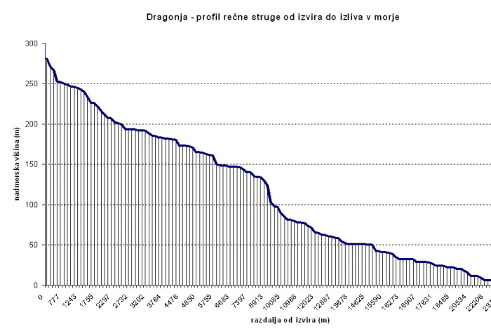 Gradient of Dragonja River.